Showing posts with label Tower. Show all posts

Saturday, September 10, 2011

Irish Round Tower, Milford


Why are there so many stone towers in New England? Because Rock is abundant in the region? While I was in the Midwest for a few years, I didn't come across a single stone tower... Now my guess game starts here: when the European settlers cultivated the land they needed to clear chunks of rock. Creating a mound after mound of rock pile was way too boring and impractical. Instead of doing so, they piled rocks up for boundary hedges. That's practical, but it's not quite a fun yet.

Yet Puritans didn't fancy the concept of fun, after zillions of boundaries they might become "creative" with the use of the cleared rock: "Why don't we create some watching towers? We need to keep our properties free from intruders!" Ok, it does sill sound full of practicality sans fun, but you can at least tweak the design to distinguish one tower from another. And then it became a part of vernacular architectural style... That's my complete fancy.

(I'm not the only one fantasizing about New England towers' origins; take a look at the case with Newport Tower in Rhodes Island!)


One day, my Irish husband B. said: "those towers look like medieval towers in Ireland. Maybe there's something to do with Irish." Huh, good point. Come to think of it, the Irish field is as rocky as the New England counterpart. Not surprisingly, our state Massachusetts has the only Irish Round Tower in North America!


The Tower is in a Roman Catholic cemetery in Milford. St Mary Cemetery of Milford was established in 1839, and the tower was built in 1894 to commemorate Irish immigrants of the town. Milford is notable for its Milford Granite. The pink granite stone become fashionable during the 1870's, and the business trend supplied employment to the immigrants.

The supply of stone (nice one!) and Irish masons were plentiful, why not build an Irish round tower, right?


This cemetery is serenely quiet. I know, cemeteries are the synonym of quiet, but there are different tones in it. For example, state hospital cemeteries are sadly quiet. Well maintained cemeteries are peacefully quiet. Mt. Auburn Cemetery in Cambridge is lively quiet... I know it sounds strange, but the cemetery is always filled with birds and animals!

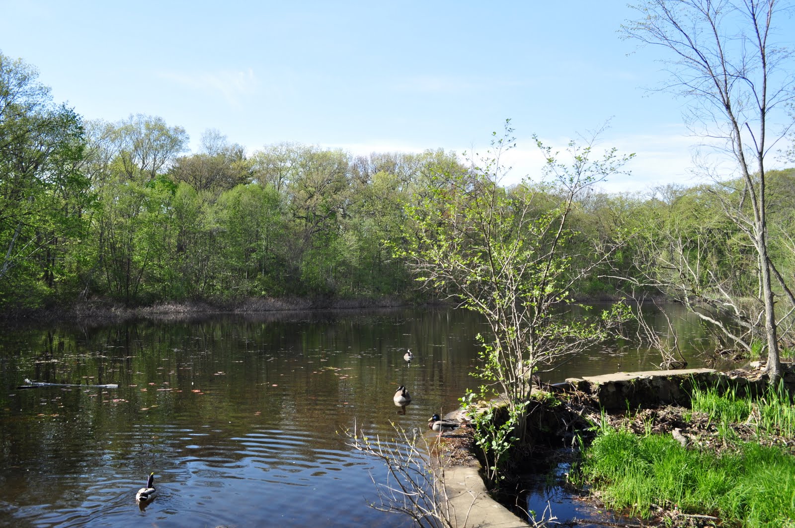
The Irish Tower sits on the edge of a pond. There is a huge rock by the tower. Under the rock, there is a man made cave of which entrance is furnished like a catacomb. The entrance is sealed with blocks of stone, and there is no way to peek inside. What's inside? Why is it sealed like that?


Wait a second, a tower and a catacomb... that sounds kinda symbolic doesn't it? I mean the motifs of man and woman are next together...

Immaculate conception?!

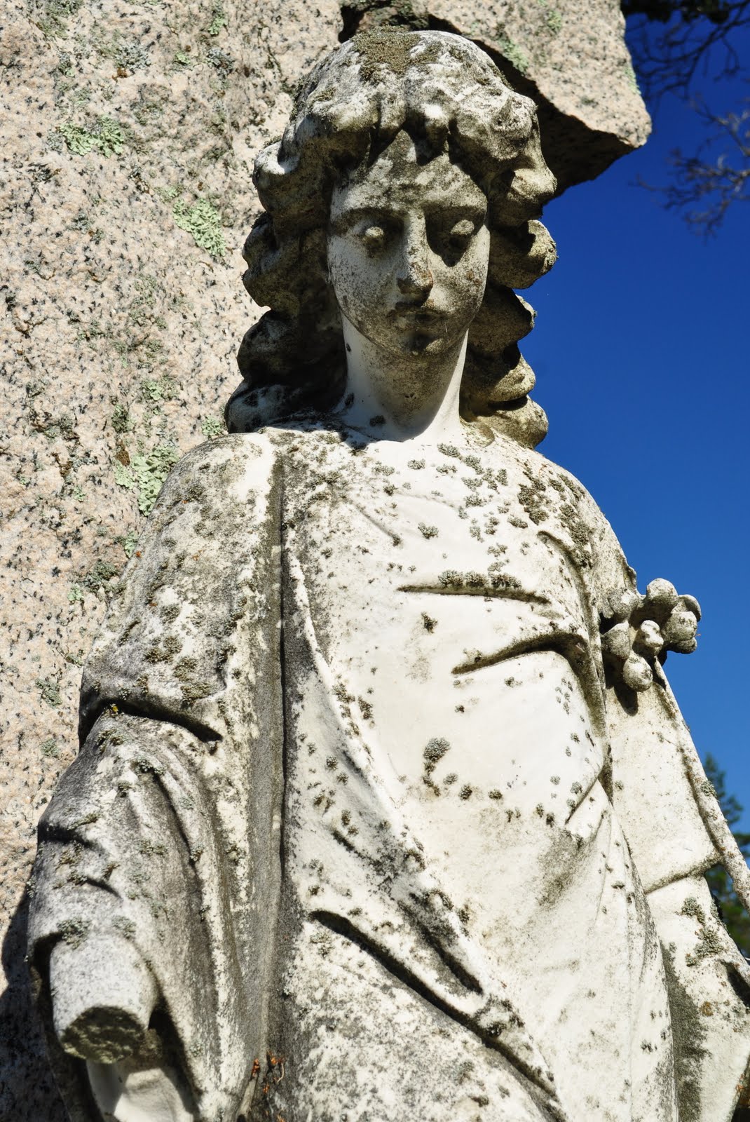
A cemetery is a great place to pick up interesting motifs and symbols. This cemetery is filled with Gaelic motifs. In addition to the Virgin Mary, many gravestone had a Celtic cross, serpentine, shamrock, and that tangled vine like thing (excuse my crude knowledge).

Needless to say, many gravestones are curved Milford Granite. I forgot to mention, the tower is made by Milford Granite blocks, too.

Close up of pink Milford Granite

I found a few pauper graves in the cemetery. I recently learned that many cemeteries in the country have pauper sections. Surrounded by non-pauper Milford granite gravestones, what fate drove them to such a numberless, austere gravestones. There may be no clues to tell their life story from a mere number, but we all have to keep in mind that even they have been labeled as "paupers", each person had a history as important as the rest of us.


After finishing my investigation, I was heading back to my car parked on the edge of the cemetery. The north side of the cemetery was next to a woodland of which ownership was not certain to me. There was newish wires in the woods which seemed to show the boundary between the cemetery and the rest of the forest.

As I walked by the woods, I was wondering who is the owner of that part of property. I was scanning for some nature trails, and suddenly mysterious wooden crosses jumped into my eyes.


The height of the cross was about 3 ft (a meter) high. From a quick observation, there were total 13 crosses on the edge of the cemetery property. (I have to say I don't like the number "13" in this context...) The plot seemed to be cleared recently as I noticed some sawdust on the ground.

As you can see from the pictures above, there were numbered plates on the crosses, indicating there seems to be an effort to distinguish one from another. Are those crosses pauper graves? Or are those recently found burial spots that their existences were somewhat forgotten from us? 


Locate Irish Round Tower @ Google Map

St Mary Milford: http://www.stmarymilford.org/
MACRIS database: http://mhc-macris.net/Details.aspx?MhcId=MIL.802
MACRIS database: http://mhc-macris.net/Details.aspx?MhcId=MIL.900 
 A towering mystery, the Greater Grafton Blog: http://greatergrafton.com/2010/01/06/a-towering-mystery-is-this-an-irish-round-tower/

Tuesday, July 26, 2011

Stone Tower, Lynn


I love Lynn Woods. Since I  "discovered" the place a year ago, I've been visiting there multiple times. People I meet on the trail are very friendly. Each time I greet them, they show me a genuine smile and throw some conversations. It has a good vibe, my kind of good vibe.

Walden Pond

Lynn Wood Reservation was founded in 1881. The 2,200 acre (9 km2) of woodland is dotted with lots of rocks and boulders; the most famous one would be Dungeon Rock. I will cover the rock in a later post. So stay tuned.

Rocks, rocks, rocks...

I love Lynn Woods not only because of the funky atmosphere filled with rocks and boulders. If you visit any reservations in Massachusetts, you'll likely come across a stone tower built by the WPA during the 30's. Yes, the job creation tower, I'd say. Lynn Woods is no exception.

I've been rather obsessively covering those towers in my blog, and the tower I'm going to introduce today is the third tower in the Lynn-Melrose-Medford area; finally the WPA stone tower triangle has completed.

Then today's tower:

Burrill Stone Tower, Lynn

I have to say every WPA tower is made equal, but personally, this is the handsomest one. (Am I stirring up a controversy?) It looks like a pencil shaped medieval dungeon tower!

This 48 ft (15m) tall stone tower was created by the WPA masons in 1936 to watch out for fire. It sits on the 285 ft  (87m) high Burrill Hill, the highest point in Lynn.


I was informed by a reader that the tower was recently refurbished, hoping to climb up the tower to the top. My expectation was very high; I was so exited that I began to regard Lynn Woods as the theme park for rocks, the mineral one, and the tower as the anchoring castle of the theme park.

Thank you Mr. & Mrs. Richardson for restoring my favorite tower!

I reached the top of Burrill hill, and went up the entrance stairs leading to the tower gate. Alas, it was closed, locked! I later learned that the tower was available by appointment only. I have to confess, I am too lazy to plan even a few days ahead.


At least, I tried to peek through the heavy iron gate to see the interior; it did look like it's in a great shape. How do I know? Look at the photo I took a year ago:

Watch out for...what? Aim the head?!

Why are kids nowadays obsessed with zombies? If you have a time to manifest your apathy towards the society we are in by doodling onto my favorite tower, why don't you stack some stone? Like building a mini Stone Tower or something. Or wait, they might really see zombies, leaving me a valuable tip for combating them?


Check out another fabulous tower in Lynn: High Rock Tower and Stone Cottage, Lynn

Locate Stone Tower, Lynn @ Google Map

Friends of Lynn Woods: http://www.flw.org/landmarks.html#stone_tower
Trail map, Friends of Lynn Woods (pdf): http://www.flw.org/pdf_files/lwmap.pdf
Burrill Stone Tower, MACRIS: http://mhc-macris.net/Details.aspx?MhcId=LYN.976

Sunday, May 22, 2011

Bear Hill Tower, Stoneham

Bear Hill Tower

Few weeks ago, I went to Wright's Tower in Medford, the tower looking down the Medford section of I-93. The tower sitting on a hill at the Middlesex Fells Reservation was built as a part of the Works Progress Administration (WPA) projects during the 30's to ease the unemployment. I personally call those towers as "job creation towers". Quite amount of job seemed to be created by stacking Massachusetts stone into towers.


When I learned about another tower in the Fells called Bear Hill Tower, I had no idea where it was. As Dave's Photo Blog calls as "tower 2", it is tucked behind of the north end of the Fells. Distance wise, Bear Hill Tower is very close to I-93, but have you ever seen it from the highway? I'm not talking about Wright's Tower. Unlike the popular sister tower, Bear Hill Tower is invisible from I-93. I guess it's a trick of terrain.

If you see I-93 and a gravel heap on your left, you are in

The other reason why the awkward position Bear Hill Tower is in is: how do we get there? As Dave's Blog suggests, the best, easiest route is from exit35 on I-93 South. I have to explain there is NO exit35 on I-93 North...how weird. Anyway, please consult for a map for direction.

We somehow managed to park our car at a nondescript parking lot. I and B. weren't sure that's the right place, but the doubt was somewhat erased when excited two big dogs sprouting out from a car next to ours. I thought those buddies were going to eat me. After you secured a parking spot, the job is 90% done. Just follow an uphill trail for few minutes. 


A friend called my cell. I explained to her that we were on a trail.

"So, you are with B."

"Yes."

"Good. Because my friend saw a bear on a trail in New Hampshire."

I was about to say "Yeah, it's good because if we happen to see a bear, we could use each other as a bait."

But that's a kind of things you should keep in your mind only; a bad joke. Anyway, the big canines we met at the parking would be more than happy to pick a fight with a bear...Wait, wait, we were on BEAR HILL!!


The tower was adjacent to a functioning water holder. The tower or water holder; which one was built first? (Note on 07/09/2011: Bear Hill Water Storage was completed in 1986 Source)

Like Wright's Tower, I thought Bear Hill Tower was a job creation tower by the WPA. But cement finish isn't their cup of tea. It has to be stone cladding!


Apparently, the history of Bear Hill Tower was much older than I expected. There had been a wooden observation tower on Bear Hill. The installment of an electric trolley station at Sheepfold (Map) in 1910 resulted an increased visitors to the Fells. You can imagine the early 20th century landscape of leisure from such trail names as Soap Box Derby Track and Railroad Trail. In accordance with the establishment of the trolley station, the wooden tower on Bear Hill was replaced by a reinforced concrete tower planned by the Stickney & Austin in the same year the station was opened. (from Friends of the Fells)

Is this 100 years old? Are you serious? Somehow I didn't want to believe the information.

Let's make sure it's safe...


The spiral steps seemed to go on forever because the wide openings (thanks, reinforced concrete) made me feel rather insecure. I don't recommend the tower to people with acrophobia or agoraphobia.  

Looking closed New England Memorial Hospital

I couldn't recognize I-93, and the view of downtown Boston wasn't as striking as Wright's Tower's. Instead, the view of Spot Pond was nice.


Why was this tower built in a first place? In general the WPA towers were built primarily for functional purpose like watching out for a forest fire and/or German U-boat. My guess is that Bear Hill Tower was solely built for a leisure purpose. As a panorama went out of a fashion of leisure, the water holder was installed right next to the tower; I could see the top surface of the holder very well from the tower. But nowadays, an array of surveillance cameras seems to take place of the tower. Poor Bear Hill Tower. 


Locate Bear Hill Tower @ Google Map

A Bear Hill Tower Photo essay, Dave's Photo Blog: http://www.davesphotoblog.com/2009/04/11/a-bear-hill-tower-photo-essay/
Map, Friends of the Fells: http://www.fells.org/visit/map.cfm
History, Friends of the Fells: http://www.fells.org/thefells/history.cfm

Sunday, May 8, 2011

Wright's Tower, Medford


It's the tower on top of the hill looking down Medford part of I-93. Each time I was on I-93 North around exit 33 -- often stuck in traffic jam with Boston honkers -- I always thought how great it would be looking down us the earth crawlers.


Wright's Tower is named after Elizur Wright. A successful businessman in the field of life insurance, he advocated for establishing the Middlesex Fells Reservation in the late 19th century. This 2,575 acres of woodland spans 5 cities. The tower is on the south end of the park, sitting on top of the 243 ft (74m) high Pine Hill.

Before the woodland became the reservation, the area was an active commercial resource. It used to provide timber, gravel, and ice even exported to India. Such trail names as Query Road and Silver Mine Path tell the history of the Fells.


I found little tricky to get to the reservation, but oh boy, it was worth while going there. The late spring finally came, and the pond was filled with life: turtles, snakes (some would cringe with the idea but just a garden snake), Mimicry Ducks, and a pair of geese with fluffy offspring.


While I was taking picture of chicks, kids found out why I wasn't moving even a bit. Holding a camera, they were trying so hard to control the excitement in order to get as close as possible to the birds. I was also quietly surprised how such a lovely place existed along I-93.

I forgot why I went to the Fells...The tower!

You should always follow others; why did I take a rough, rocky trail on the right?

It should only take five minutes to get to the tower, but I somehow ended up wandering in the woods by choosing a rough, rocky trail leads to nowhere; the morale of the story is you should always follow the beaten path. But if I followed the maxim, this blog would not exist (a desperate justification.)


The tower's gate was locked. From outside, it looked more like a fortress; you peek from the slits to shoot arrows and throw god knows what.

I have seen this style of stone cladding before; piling up the dug up stone. The benefit of the style is that not only workers don't need to carry the stone for a distance to ditch somewhere but also they can decorate structures a la Massachusetts. This practical architectural style was popular among on-top-of-the-hill structures built by the Works Progress Administration. Wright's Tower is no exception; as a part of job creation during the Great Depression, the tower was built during the 30's by the WPA. It's 3rd* of the kind I have seen in the state.


It was right after 5 clock, I-93 was clogged with cars just got out from work. Muwahahahaha, it's so great to observe traffic jam!! I finally joined the club looking down you earth crawlers!!


Probably I was the only one with the evil laughter. Everyone on top of the hill was laid back, enjoying the spring that finally came. It occurred to me that this spot would be great during the leaf peeping season, too.


Locate Wright's Tower @ Google Map

Click picture to enlarge

History, Friends of the Fells: http://www.fells.org/thefells/history.cfm
Map, Friends of the Fells (PDF): http://www.fells.org/file/Fells%20Reservation%20Map.pdf