Showing posts with label Industry. Show all posts

Thursday, September 29, 2011

Mercantile Wharf Building, Boston


Mercantile Wharf Building is one of the creations of Gridley James Fox Bryant. Prolific in the mid 19th century, he represented the Boston Granite Style thorough Charles Street Jail (1851), Washington Tower at Mt Auburn (1854), and the Cambridge Poor Farm(1851).


Completed in 1857, Mercantile Wharf Building is in an once busy dock area. The building stored goods for the adjacent Quincy Market.

1946 Map of Boston, Blue * indicates the loc. of Mercantile Wharf Bld: From Mytopo
Upper Balloon: Mercantile Wharf Bld, Lower Balloon: Quincy Mkt: From Google Map

Currently, the Quincy Market and Mercantile Wharf Building are divided by two busy through ways. But it used to be a stone's throw distance; upon the construction of the much dreaded elevated I-93 (John F. Fitzgerald Highway) in the 50's, the building was "chopped into a half" to make a way for the the highway. If you look below pictures of the both sides, it is quite noticeable what happened to the south side.

North side
South side

I always thought the bare brick side is sort of cool, but I didn't realize it was a scar the urban renewal had left to this building; it torn the fabric of the community and the forcibly particled space would never be united again as a coherent neighborhood (For more about the division caused by the elevated I-93, please refer to my previous post).

The building was converted to a multi-use commercial space and apartment in 1976. On a sunny weekend, the area is filled with people. Looking over a waterfront park with a carousel, Mercantile Wharf Building has sure not only changed its purpose but witnessed the neighborhood transformation.


Locate Marcantile Wharf Building @ Google Map

http://mhc-macris.net/Details.aspx?MhcId=BOS.5216
http://mhc-macris.net/Details.aspx?MhcId=BOS.5221
http://archboston.org/community/showthread.php?t=1030
http://bostonlookingbackward.wordpress.com/2010/11/17/the-rise-and-fall-of-the-mercantile-wharf%C2%A0building/
http://historical.mytopo.com/getImage.asp?fname=bsns46ne.jpg&state=MA (1946 Boston South, Northeast)

Sunday, September 18, 2011

Hoffman Building, Boston


Hoffman Building, Lovejoy Wharf, Submarine Signal Building, Schrafft's Candy Factory Quincy Cold Storage... I don't know which name rings a bell to you, but it's that abandoned loft just before you go deep under the Big Dig. When you are on I-93 south, maybe you are preoccupied by being on the Zakim Bridge or by the sight of TD Bank Garden on your right. If you turn your head opposite from the Bruins... that's the one I'm talking about. If you still don't get it, forget about it. Just drive safe.   

TD Bank Garden and Zakim Bridge

The way you can get to this loft as close as possible is from a foot path under the Charleston Bridge. On a weekend day, the ducky amphibious mobile and the green-orange trolley bus with happy tourists constantly pass on the Charleston Bridge. No one would be talking about this abandoned loft. You cannot beat the magnificent sight of the bridge and the Bruins, I understand. 


The jetty has been left to collapse. How long has it been abandoned? From the billboard on top of the roof, there seems to be a plan to convert this wharf to a condo or something. But I don't think this will happen any time soon.

Am I the only one thinking the walkway is "temporarily" closed due to "repairs"?

The sign on North Washington Street entrance says this is "Submarine Signal Building". The Submarine Signal Company was founded in 1901, and later acquired by the American Appliance Company (which became a guided missile company Raytheon) in 1945.

The building itself is constructed in 1907, so it is relatively safe to assume the building had been occupied by the Submarine Signal first. Later the building became a storage for the local candy company, Scrafft's ice cream division. The last major occupant seems to be the DMV under the name of the Hoffman Building. I know, the list of occupants sounds totally random.


Now the jetty that must have loaded or unloaded mechanical instruments for the Submarine Signal Company or the ice cream (yummy!) for Schrafft's is left abandoned.

After the Big Dig was finally dug in 2007, the area that had been isolated by the elevated I-93 became the prime target for redevelopment. The Hoffman Building was no exception; in the summer of 2007, a plan to convert "Lovejoy Wharf" into a residential complex with an automated garage and retail stores was launched. But the conversion was blocked by the residents at a nearby condo who showed a concern that the Lovejoy's plan with a partial 14-story unit would block their view of the Charles. Things came to a halt here.

So the brief history of that abandoned wharf ends here. But I still don't know why the developer named the building as "Lovejoy Wharf". Is this Mr. or Ms. Lovejoy's property? To be honest, it does sound like this is the wharf where the Love Boat docks.


Locate Hoffman Building @ Google Map

http://mhc-macris.net/Details.aspx?MhcId=BOS.1915
http://www.bizjournals.com/boston/stories/2009/10/19/story7.html?page=all
http://www.bostoncondogroup.com/Condos/Lovejoy-Wharf.aspx

Tuesday, July 12, 2011

Echo Bridge & Elliot Manufacturing Co., Newton-Needham

Continue from: Echo Bridge, Newton-Needham

Former Elliot Manufacturing Company 

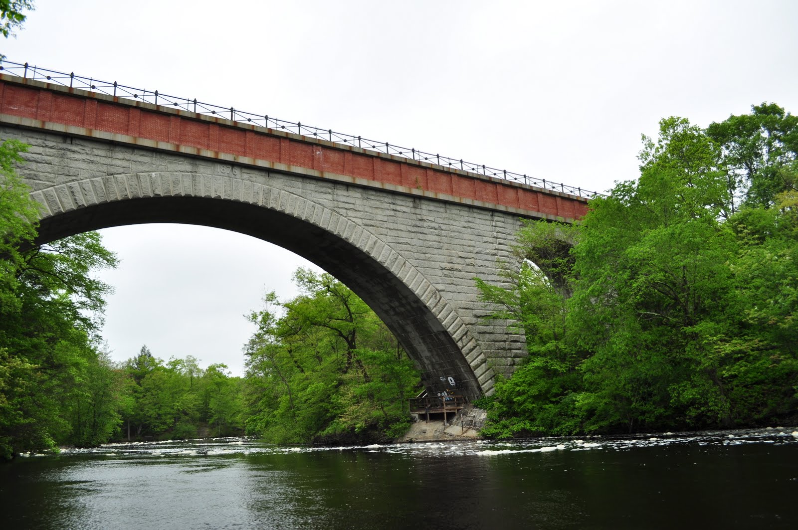
The construction of Echo Bridge completed in 1876 as a part of the Sudbury Aqueduct. The waterway began operating in 1878 to transport water from Framingham to Chestnut Hill for the purpose of supplying drinking water to the Metropolitan Boston area. 

Echo Bridge

Currently utilized as a backup waterway, the aqueduct was in full use until 1978. Echo Bridge is now open to public as a part of Hemlock Gorge Reservation.

After investigating around the gorge (see the previous post: Echo Bridge, Newton-Needham), I went up to the bridge by approaching from the Newton side.


The first feature I noticed was how the bridge surface was slightly inclined like a roof slope. The rain water drips easily from the surface, and snow won't accumulate to the degree the bridge collapses. From an eye of a civil engineer, I guess that is a common practice. But I was simply impressed by the ingenious design!


The original parapets were blocked by a tasteless...uh...functional modern chain link fence. But look closely at the original fence; you can find the emblem reads as "BWW"... It must be the acronym of "Boston Water Works". At first, I mistook the logo as the one of a German automaker.


From the top of the bridge, the view of the gorge was impressive, made me forget the fact that I was in so-called Boston suburb. Looking north, the emerald colored  trees (I visited in May) were very beautiful but the noise from Route 9 and the mysterious foam on the river reminded  me a gentler version of the "Crying Indian".

North view, Rote 9 on the upper right

Looking south, the view of the old cotton mill factory was very quaint; the unchanged view for the last few centuries. Although, the sight of the mill could have been a "modern" eyesore back in the 19th century.

South view

The old mill was established prior to the arrival of Echo Bridge Aqueduct. The mill, Elliot Manufacturing Company replaced the original industrial complex consisted with a saw mill (dates back in the late 17th century), grist mill, fulling mill, snuff tobacco mills, and blacksmith related shops in 1821. The company manufactured cotton until 1884, and then silk until 1962. Like Lowell's mills, the dam must have been used to power the looms.

Thinking about the controversy of the construction of the Suiro-kaku waterway in 19th century Kyoto, I was wondering whether the establishment of the cotton mill was regarded as the modern industrial eyesore that disturbs the beauty of the gorge. But the saw mill had been existed on the location since 17th century; the gorge was always regarded as the industrial site...

On the contrary to my initial thought, the arrival of the Elliot Manufacturing Company might have been a welcoming change to the neighborhood (especially for the managerial class) because the snuff mills were regarded as  "a temptation to the many of the people to indulge in the filthy habit" (from History of Newton)!


I crossed the Newton-Needham line towards Needham. The bridge ended but the underground aqueduct kept going on. When I visited the Wachusett Aqueduct and its overhead bridge, the area was an off-limit. So walking on Echo Bridge and  the Sudbury Aqueduct was very exiting!


There was a huge rock by the aqueduct route. Looking closely at the rock, there were remains of drilling holes, suggesting it had been a much bigger rock blocking the aqueduct route. What did the workers use to crash the rock? Did they drill those holes to insert cartridges to blow up the rock?

The greenway ended abruptly after a few minutes walk. The beltway was in front of me. The busy traffic noise of I-95 reminded me that the afternoon rush hour started. I looked my watch, it was past 3 o'clock.


Locate Echo Bridge @ Google Map
Also read: Wachusett Aqueduct, Northborough

Elliot Manufacturing Company, Macris database: http://mhc-macris.net/Details.aspx?MhcId=NWT.89
Discover Historic Newton Falls (PDF): http://www.ci.newton.ma.us/cdbg/hist/upper%20%20falls.pdf
History of Newton, Massachusetts (google book): http://books.google.com/books?id=sxOAuf1PSC8C&pg=PA269&lpg=PA269&dq=Elliott+Manufacturing+Company+newton&source=bl&ots=lun8YI4pKB&sig=X8oaT_UstupC5eEvJsro7_at5nI&hl=en&ei=T5cYTqbWKse_gQfA_K0a&sa=X&oi=book_result&ct=result&resnum=4&ved=0CDMQ6AEwAw#v=onepage&q&f=false

Sunday, July 3, 2011

Echo Bridge, Newton-Needham


Echo Bridge is a part of the Sudbury Aqueduct. The aqueduct connects the Sudbury Reservoir in Framingham and  the Chestnut Hill Reservoir by Boston College. The linear distance between the two is about 20 miles. The construction of the Echo Bridge finished in 1876, and the aqueduct began operating in 1878 . The Sudbury aqueduct was active until 1978 and currently utilized as a backup waterway. This well maintained, beautiful bridge is currently open to public as a part of  Hemlock Gorge Reservation.

An oncoming car slowed down, sorry I must have looked like a cop with a seed gun

Starting from the mid 19th century to 1930's, four aqueducts -- the Chochichuate, Sudbury, Wachusett, and Quabbin Aqueducts -- were constructed to supply water to the Metropolitan Boston area. Only the latter two are still in use.


Echo Bridge aqueduct crosses Hemlock Gorge part of the Charles. I wonder whether the information becomes handy to you in the future, but the gorge splits the town of Needham and Newton; the Echo Bridge spans over the two towns. The valley is surrounded with Hemlock tree, hence the name, and from a first look, it looks very serene. However, the bridge is in the vicinity of the beltway (I-95) and a busy commuter road (Route 9), and the sound of traffic is consistently heard from those roads.


What is this mysterious, cappuccino-like foam on the river? I must say I'm bit concerned with the water quality. The bubbles are formed because the water has been stirred up by the man-made water fall nearby. I assume the fall was used to power weaving machines in the old mill, which currently converted to an office and shop space.


I forgot to explain it to you: why is this bridge named "Echo Bridge"? If you position yourself like the below photo and shout, your voice echos. Rather simple naming...Did I try? No, I was alone and bit embarrassed to try. I know I should have...Well, report me the result of your "yo-ho".


Shall we go up to the bridge?


Continue to: Echo Bridge & Elliot Manufacturing Co.

Locate Echo Bridge, Newton-Needham @ Google Map

Sudbury Aqueduct, Waymarking: http://www.waymarking.com/waymarks/WM50N0_Sudbury_Aqueduct_Echo_Bridge_Needham_MA

Sunday, June 5, 2011

Stuck in the Emerson Iron Lung

(a follow up of: Emerson's Iron Lung and Quonset Hut, Cambridge)


Recently, I visited the Public Health Museum at Tewsksbury Hospital and came across an object I mentioned in my past post.

I live close to the former main office of J.H. Emerson Co. in North Cambridge. The company was the leading manufacture of a negative pressure ventilator a.k.a Iron Lung during the polio outbreaks between the 40's and 50's. It was a temporal measure for the majority of the patients, but some remained to rely on an Iron Lung permanently.


After the development of the vaccine in the 60's, the company had been manufacturing the "cough assist" products. The company was sold in 2007, and the office became empty. But rusty Iron Lungs in a Quonset Hut were left visible from the sidewalk for few years. They are already cleared, and the Quonset Hut is waiting to be demolished.

More modern one

At the Public Health Museum, I was with two museum guides. (Hey, I'm a VIP!) Looking at a more modern version of an Iron Lung embellished with cute stickers, one of the guides -- a lady in my mom's age -- told me that she personally knew people had contracted polio.


The other guide, a tough looking grandpa with Boston accent, is a retired hospital worker at the Tewksbury. Looking at an older version of the machine, he mentioned about the photo full of Iron Lungs taken during the highest of the epidemic. What a coincidence, I've cited the photo in my past entry... In his generation, this is the vision of the polio epidemic.


He told me the PBS crew used the above machine to shoot a documentary.

"They recreated the hospital ward, and a child actor, a boy, went inside of this."

"If you were the child actor, could you be inside of this ?"

"No thanks."

He frowned a bit. The voice had a tone admiring the kid's professionalism. I agree with him, no thanks for me, either.

He or she would sure learn how to tell a person approaching from the shoes.

"Why is there a mirror here?", I asked.

"They were lying down, the bodies were inside of the tank. You couldn't move your neck towards a person talking to you."


There was a metal plate; manufactured by J. H. Emerson Co. at an address in Cambridge. Yep, it's from North Cambridge.

FDR and polio

Locate Public Health Museum/ Tewksbury Hospital @ Google Map

Public Health Museum: http://www.publichealthmuseum.org/index.htm
Last breath, Mass High Tech: http://www.masshightech.com/stories/2007/05/14/story1-Last-breaths.html

Sunday, May 22, 2011

Bear Hill Tower, Stoneham

Bear Hill Tower

Few weeks ago, I went to Wright's Tower in Medford, the tower looking down the Medford section of I-93. The tower sitting on a hill at the Middlesex Fells Reservation was built as a part of the Works Progress Administration (WPA) projects during the 30's to ease the unemployment. I personally call those towers as "job creation towers". Quite amount of job seemed to be created by stacking Massachusetts stone into towers.


When I learned about another tower in the Fells called Bear Hill Tower, I had no idea where it was. As Dave's Photo Blog calls as "tower 2", it is tucked behind of the north end of the Fells. Distance wise, Bear Hill Tower is very close to I-93, but have you ever seen it from the highway? I'm not talking about Wright's Tower. Unlike the popular sister tower, Bear Hill Tower is invisible from I-93. I guess it's a trick of terrain.

If you see I-93 and a gravel heap on your left, you are in

The other reason why the awkward position Bear Hill Tower is in is: how do we get there? As Dave's Blog suggests, the best, easiest route is from exit35 on I-93 South. I have to explain there is NO exit35 on I-93 North...how weird. Anyway, please consult for a map for direction.

We somehow managed to park our car at a nondescript parking lot. I and B. weren't sure that's the right place, but the doubt was somewhat erased when excited two big dogs sprouting out from a car next to ours. I thought those buddies were going to eat me. After you secured a parking spot, the job is 90% done. Just follow an uphill trail for few minutes. 


A friend called my cell. I explained to her that we were on a trail.

"So, you are with B."

"Yes."

"Good. Because my friend saw a bear on a trail in New Hampshire."

I was about to say "Yeah, it's good because if we happen to see a bear, we could use each other as a bait."

But that's a kind of things you should keep in your mind only; a bad joke. Anyway, the big canines we met at the parking would be more than happy to pick a fight with a bear...Wait, wait, we were on BEAR HILL!!


The tower was adjacent to a functioning water holder. The tower or water holder; which one was built first? (Note on 07/09/2011: Bear Hill Water Storage was completed in 1986 Source)

Like Wright's Tower, I thought Bear Hill Tower was a job creation tower by the WPA. But cement finish isn't their cup of tea. It has to be stone cladding!


Apparently, the history of Bear Hill Tower was much older than I expected. There had been a wooden observation tower on Bear Hill. The installment of an electric trolley station at Sheepfold (Map) in 1910 resulted an increased visitors to the Fells. You can imagine the early 20th century landscape of leisure from such trail names as Soap Box Derby Track and Railroad Trail. In accordance with the establishment of the trolley station, the wooden tower on Bear Hill was replaced by a reinforced concrete tower planned by the Stickney & Austin in the same year the station was opened. (from Friends of the Fells)

Is this 100 years old? Are you serious? Somehow I didn't want to believe the information.

Let's make sure it's safe...


The spiral steps seemed to go on forever because the wide openings (thanks, reinforced concrete) made me feel rather insecure. I don't recommend the tower to people with acrophobia or agoraphobia.  

Looking closed New England Memorial Hospital

I couldn't recognize I-93, and the view of downtown Boston wasn't as striking as Wright's Tower's. Instead, the view of Spot Pond was nice.


Why was this tower built in a first place? In general the WPA towers were built primarily for functional purpose like watching out for a forest fire and/or German U-boat. My guess is that Bear Hill Tower was solely built for a leisure purpose. As a panorama went out of a fashion of leisure, the water holder was installed right next to the tower; I could see the top surface of the holder very well from the tower. But nowadays, an array of surveillance cameras seems to take place of the tower. Poor Bear Hill Tower. 


Locate Bear Hill Tower @ Google Map

A Bear Hill Tower Photo essay, Dave's Photo Blog: http://www.davesphotoblog.com/2009/04/11/a-bear-hill-tower-photo-essay/
Map, Friends of the Fells: http://www.fells.org/visit/map.cfm
History, Friends of the Fells: http://www.fells.org/thefells/history.cfm