
Wednesday, October 19, 2011
Saturday, October 15, 2011
A greeting from Shuko K.
Dear Readers,
I'm changing my blog title from Creepy-chusetts, Strange-chusetts to The Reversed View of Massachusetts!
The new URL will be: http://reversedview.blogspot.com/ . I'll be arranging to automatically relocate from here to there once I settle in there;the only thing you need to do is just keeping in mind about the change.(note: added on 10/19/11)
The essence of the blog will be the same, but I'd like to focus on more about people who were/ are associated with the places I investigate. I'll explain the meaning of this enigmatic title under new blog. However, in next few month the number of posts I publish will be less than it used to be. It's just temporary. A lot of things are happening, I wish I can investigate those places all day long!
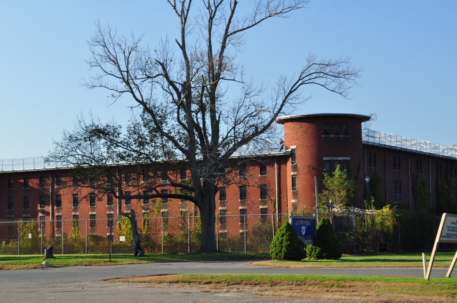
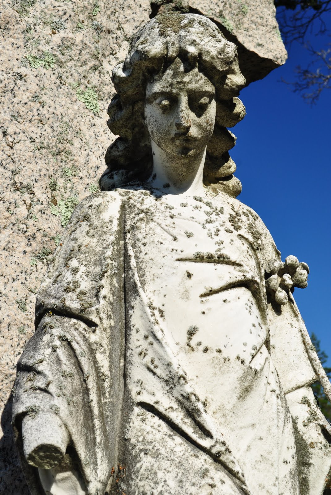
Recently I went to Bridgewater to investigate the Bridgewater State Hospital Cemetery to find one specific gravestone. I wanted to connect a story of one patient and a nameless grave stone. I'll post my findings shortly in The Reversed View of Massachusetts, but until then, here's the sneak peak:


Aren't they something?
Shuko K.
I'm changing my blog title from Creepy-chusetts, Strange-chusetts to The Reversed View of Massachusetts!
The new URL will be: http://reversedview.blogspot.com/ . I'll be arranging to automatically relocate from here to there once I settle in there;
The essence of the blog will be the same, but I'd like to focus on more about people who were/ are associated with the places I investigate. I'll explain the meaning of this enigmatic title under new blog. However, in next few month the number of posts I publish will be less than it used to be. It's just temporary. A lot of things are happening, I wish I can investigate those places all day long!
Recently I went to Bridgewater to investigate the Bridgewater State Hospital Cemetery to find one specific gravestone. I wanted to connect a story of one patient and a nameless grave stone. I'll post my findings shortly in The Reversed View of Massachusetts, but until then, here's the sneak peak:

Aren't they something?
Shuko K.
Thursday, September 29, 2011
Mercantile Wharf Building, Boston

Mercantile Wharf Building is one of the creations of Gridley James Fox Bryant. Prolific in the mid 19th century, he represented the Boston Granite Style thorough Charles Street Jail (1851), Washington Tower at Mt Auburn (1854), and the Cambridge Poor Farm(1851).


Completed in 1857, Mercantile Wharf Building is in an once busy dock area. The building stored goods for the adjacent Quincy Market.

1946 Map of Boston, Blue * indicates the loc. of Mercantile Wharf Bld: From Mytopo

Upper Balloon: Mercantile Wharf Bld, Lower Balloon: Quincy Mkt: From Google Map
Currently, the Quincy Market and Mercantile Wharf Building are divided by two busy through ways. But it used to be a stone's throw distance; upon the construction of the much dreaded elevated I-93 (John F. Fitzgerald Highway) in the 50's, the building was "chopped into a half" to make a way for the the highway. If you look below pictures of the both sides, it is quite noticeable what happened to the south side.

North side
South side
I always thought the bare brick side is sort of cool, but I didn't realize it was a scar the urban renewal had left to this building; it torn the fabric of the community and the forcibly particled space would never be united again as a coherent neighborhood (For more about the division caused by the elevated I-93, please refer to my previous post).
The building was converted to a multi-use commercial space and apartment in 1976. On a sunny weekend, the area is filled with people. Looking over a waterfront park with a carousel, Mercantile Wharf Building has sure not only changed its purpose but witnessed the neighborhood transformation.

Locate Marcantile Wharf Building @ Google Map
http://mhc-macris.net/Details.aspx?MhcId=BOS.5216
http://mhc-macris.net/Details.aspx?MhcId=BOS.5221
http://archboston.org/community/showthread.php?t=1030
http://bostonlookingbackward.wordpress.com/2010/11/17/the-rise-and-fall-of-the-mercantile-wharf%C2%A0building/
http://historical.mytopo.com/getImage.asp?fname=bsns46ne.jpg&state=MA (1946 Boston South, Northeast)
Sunday, September 18, 2011
Hoffman Building, Boston

Hoffman Building, Lovejoy Wharf, Submarine Signal Building, Schrafft's Candy Factory Quincy Cold Storage... I don't know which name rings a bell to you, but it's that abandoned loft just before you go deep under the Big Dig. When you are on I-93 south, maybe you are preoccupied by being on the Zakim Bridge or by the sight of TD Bank Garden on your right. If you turn your head opposite from the Bruins... that's the one I'm talking about. If you still don't get it, forget about it. Just drive safe.

TD Bank Garden and Zakim Bridge
The way you can get to this loft as close as possible is from a foot path under the Charleston Bridge. On a weekend day, the ducky amphibious mobile and the green-orange trolley bus with happy tourists constantly pass on the Charleston Bridge. No one would be talking about this abandoned loft. You cannot beat the magnificent sight of the bridge and the Bruins, I understand.


The jetty has been left to collapse. How long has it been abandoned? From the billboard on top of the roof, there seems to be a plan to convert this wharf to a condo or something. But I don't think this will happen any time soon.

Am I the only one thinking the walkway is "temporarily" closed due to "repairs"?
The sign on North Washington Street entrance says this is "Submarine Signal Building". The Submarine Signal Company was founded in 1901, and later acquired by the American Appliance Company (which became a guided missile company Raytheon) in 1945.
The building itself is constructed in 1907, so it is relatively safe to assume the building had been occupied by the Submarine Signal first. Later the building became a storage for the local candy company, Scrafft's ice cream division. The last major occupant seems to be the DMV under the name of the Hoffman Building. I know, the list of occupants sounds totally random.


Now the jetty that must have loaded or unloaded mechanical instruments for the Submarine Signal Company or the ice cream (yummy!) for Schrafft's is left abandoned.
After the Big Dig was finally dug in 2007, the area that had been isolated by the elevated I-93 became the prime target for redevelopment. The Hoffman Building was no exception; in the summer of 2007, a plan to convert "Lovejoy Wharf" into a residential complex with an automated garage and retail stores was launched. But the conversion was blocked by the residents at a nearby condo who showed a concern that the Lovejoy's plan with a partial 14-story unit would block their view of the Charles. Things came to a halt here.
So the brief history of that abandoned wharf ends here. But I still don't know why the developer named the building as "Lovejoy Wharf". Is this Mr. or Ms. Lovejoy's property? To be honest, it does sound like this is the wharf where the Love Boat docks.


Locate Hoffman Building @ Google Map
http://mhc-macris.net/Details.aspx?MhcId=BOS.1915
http://www.bizjournals.com/boston/stories/2009/10/19/story7.html?page=all
http://www.bostoncondogroup.com/Condos/Lovejoy-Wharf.aspx
Saturday, September 10, 2011
Irish Round Tower, Milford

Why are there so many stone towers in New England? Because Rock is abundant in the region? While I was in the Midwest for a few years, I didn't come across a single stone tower... Now my guess game starts here: when the European settlers cultivated the land they needed to clear chunks of rock. Creating a mound after mound of rock pile was way too boring and impractical. Instead of doing so, they piled rocks up for boundary hedges. That's practical, but it's not quite a fun yet.
Yet Puritans didn't fancy the concept of fun, after zillions of boundaries they might become "creative" with the use of the cleared rock: "Why don't we create some watching towers? We need to keep our properties free from intruders!" Ok, it does sill sound full of practicality sans fun, but you can at least tweak the design to distinguish one tower from another. And then it became a part of vernacular architectural style... That's my complete fancy.
(I'm not the only one fantasizing about New England towers' origins; take a look at the case with Newport Tower in Rhodes Island!)

One day, my Irish husband B. said: "those towers look like medieval towers in Ireland. Maybe there's something to do with Irish." Huh, good point. Come to think of it, the Irish field is as rocky as the New England counterpart. Not surprisingly, our state Massachusetts has the only Irish Round Tower in North America!

The Tower is in a Roman Catholic cemetery in Milford. St Mary Cemetery of Milford was established in 1839, and the tower was built in 1894 to commemorate Irish immigrants of the town. Milford is notable for its Milford Granite. The pink granite stone become fashionable during the 1870's, and the business trend supplied employment to the immigrants.
The supply of stone (nice one!) and Irish masons were plentiful, why not build an Irish round tower, right?

This cemetery is serenely quiet. I know, cemeteries are the synonym of quiet, but there are different tones in it. For example, state hospital cemeteries are sadly quiet. Well maintained cemeteries are peacefully quiet. Mt. Auburn Cemetery in Cambridge is lively quiet... I know it sounds strange, but the cemetery is always filled with birds and animals!
The Irish Tower sits on the edge of a pond. There is a huge rock by the tower. Under the rock, there is a man made cave of which entrance is furnished like a catacomb. The entrance is sealed with blocks of stone, and there is no way to peek inside. What's inside? Why is it sealed like that?

Wait a second, a tower and a catacomb... that sounds kinda symbolic doesn't it? I mean the motifs of man and woman are next together...

Immaculate conception?!
A cemetery is a great place to pick up interesting motifs and symbols. This cemetery is filled with Gaelic motifs. In addition to the Virgin Mary, many gravestone had a Celtic cross, serpentine, shamrock, and that tangled vine like thing (excuse my crude knowledge).
Needless to say, many gravestones are curved Milford Granite. I forgot to mention, the tower is made by Milford Granite blocks, too.


Close up of pink Milford Granite
I found a few pauper graves in the cemetery. I recently learned that many cemeteries in the country have pauper sections. Surrounded by non-pauper Milford granite gravestones, what fate drove them to such a numberless, austere gravestones. There may be no clues to tell their life story from a mere number, but we all have to keep in mind that even they have been labeled as "paupers", each person had a history as important as the rest of us.


After finishing my investigation, I was heading back to my car parked on the edge of the cemetery. The north side of the cemetery was next to a woodland of which ownership was not certain to me. There was newish wires in the woods which seemed to show the boundary between the cemetery and the rest of the forest.
As I walked by the woods, I was wondering who is the owner of that part of property. I was scanning for some nature trails, and suddenly mysterious wooden crosses jumped into my eyes.


The height of the cross was about 3 ft (a meter) high. From a quick observation, there were total 13 crosses on the edge of the cemetery property. (I have to say I don't like the number "13" in this context...) The plot seemed to be cleared recently as I noticed some sawdust on the ground.
As you can see from the pictures above, there were numbered plates on the crosses, indicating there seems to be an effort to distinguish one from another. Are those crosses pauper graves? Or are those recently found burial spots that their existences were somewhat forgotten from us?
Locate Irish Round Tower @ Google Map
St Mary Milford: http://www.stmarymilford.org/
MACRIS database: http://mhc-macris.net/Details.aspx?MhcId=MIL.802
MACRIS database: http://mhc-macris.net/Details.aspx?MhcId=MIL.900
A towering mystery, the Greater Grafton Blog: http://greatergrafton.com/2010/01/06/a-towering-mystery-is-this-an-irish-round-tower/
Sunday, August 28, 2011
Examining the Cambridge Poor Farm 2-2
If you stumble upon this post, I'd recommend reading Examining the Cambridge Poor Farm 1-2 first.

Located on the most northern corner of the city of Cambridge, the Cambridge Poor Farm was established in 1851. At the almshouse, "the elderly and 'the deserving poor' lived among the sick and the insane" until its closure in 1927.
Continuing from the previous post, I've been investigating this less known piece of Cambridge history together with the 1851 Cambridge Chronicle article. What intrigues me the most is that how the historic event, philosophy, and public sentiment of the time reflected the walls of those institutions. Now, I'll continue the virtual tour. Let's go to 3rd floor.

As I have explained in the previous post, 3rd floor had the same layout as 2nd floor: consisting with the workroom and dormitories divided by sex. But there were a few notable differences between the floors. On 3rd floor, the extreme ends of the east and west wings functioned as hospital wards. Especially, the hospital ward at the men's (east) wing, two rooms were given to "inmates" who were "dangerously sick" or "in a dying stage".
One more notable distinction between 2nd and 3rd floor is that the upper floor was dedicated to the "American poor". Conversely, it meant that the floor below was allocated to the "non-American poor". Wait, wait. What does an "American" mean in the sense of 1851?
In 1847 alone, 25,000 Irish immigrated to the City of Boston to escape the Great Famine of 1845. By 1850, 1/3 of the Boston population was Irish. Our North Cambridge also hold Irish neighborhoods such as "Dublin" and "New Ireland" around the time. Those communities accommodated workers for a nearby brickyard. There had been a much smaller almshouse nearby the neighborhoods, which was eventually alternated by the almshouse I'm investigating today.


I used to naively think: "what's the matter, the 'American' and the 'Irish' speak the same language!" But when I observed how the tombstones at the Metfern Cemetery in Waltham --where some state hospital patients between 1947 and 1979 were buried-- were distinguished by Catholic and Protestant, the austere concrete blocks gave me an impression that the separation was, or some may say is, the norm of the local culture. Is it a benevolently intentioned custom to "avoid unnecessary confusion" for both sides? Or is it a fear and prejudice against the new wave of immigrants? I guess the picture is muddy; generally speaking, such a seemingly good-intentioned custom that draws a line between certain groups could lead to an established segregation practice.

From the tone of the Cambridge Chronicle article, the separation practice at this almshouse seemed to start from the "good-hearted" intention; the article proudly stats the division as "So far our knowledge extends, this is the first provision of the kind ever carried out in practice."
The Cambridge Poor Farm had a chapel on 4th floor, and I wonder how did they divide Protestants and Catholics in terms of the chapel use.
You might notice it already, but there is a one big change between the now and then picture:


Look and compare the east (right) wing for male. The male dormitory underwent an expansion in 1915. It looks like the men's dormitory stretched twice as long! But what was the implication of the expansion? Did Rev. Dwight and Bryant thought the male: female inmate ratio would be equal, but the city later realized more accommodation was required for male inmates? Even without mentioning George Orwell's observation, there are more male homeless than the female counterpart.

Only 12 years after the expansion, the city relocated the almshouse to the new City Home for Aged and Infirm on Concord Avenue. The site of the Cambridge Poor Farm was sold to the Catholic Church, and the building was converted to a parish school. Sometimes around 1999, the International School of Boston renovated the building to the current use.
My observation on the Cambridge Poor Farm ends here. I thank the Cambridge Room archivist who showed a genuine intellectual interest in my "creepy and strange" investigation and found the 160 year old article from a stack of microfilms. You should visit there! The powerful opening was cited from the Baron Barometer's Brain Blog. His stark observation on what would happen to him if he was a 19th century man sure grabbed my mind, and I'm glad such a badass guy is in 21st century Somerville!
What else I'd say... If you spent some time in this building as a student or whatever, and a certain descriptions of the building ring a bell (i.e.: "No wonder why that room used to be a hospital ward for dying men."), please feel free to leave a message or send an e-mail to: creepychusetts[at]gmail.com.

Locate Cambridge Poor Farm @ Google Map


<sources>
Cambridge Historical Commission. Survey of Architectural History in Cambridge: Report Five Northwest Cambridge. Cambridge: MIT, 1977.
"The New Alms-house." Cambridge Chronicle 22 Mar.1851: 1
Klein, Christoper. Discovering the Boston Harbor Islands. Boston: Union Park Press, 2008.
Brain Blog: History Around Every Corner: http://www.baronbarometer.com/?p=248
History of the International School of Boston: http://www.isbos.org/page.cfm?p=10
Cambridge Poor Farm, Creepy-chusetts, Strange-chusetts: http://creepychusetts.blogspot.com/2010/11/cambridge-poor-farm-cambridge.html
It dawned on me that I would have ended up there. Cerebral shunts weren’t even invented until the late 1800′s and probably not even remotely safe for most patients until the 1900′s...Eventually I would be considered invalid, and with no source of income I would be sent to the Poor Farm. Maybe I would do some light quarry work or net some fish, but more likely I would spend my days moaning in pain on a dirty floor while the orphans try to avoid me or steal my food. -- From Baron Barometer's Brain Blog

Cambridge Poor Farm
Located on the most northern corner of the city of Cambridge, the Cambridge Poor Farm was established in 1851. At the almshouse, "the elderly and 'the deserving poor' lived among the sick and the insane" until its closure in 1927.
Continuing from the previous post, I've been investigating this less known piece of Cambridge history together with the 1851 Cambridge Chronicle article. What intrigues me the most is that how the historic event, philosophy, and public sentiment of the time reflected the walls of those institutions. Now, I'll continue the virtual tour. Let's go to 3rd floor.

Click picture to enlarge -- from Cambridge Chronicle
The upper floors
As I have explained in the previous post, 3rd floor had the same layout as 2nd floor: consisting with the workroom and dormitories divided by sex. But there were a few notable differences between the floors. On 3rd floor, the extreme ends of the east and west wings functioned as hospital wards. Especially, the hospital ward at the men's (east) wing, two rooms were given to "inmates" who were "dangerously sick" or "in a dying stage".
Segregation or benevolent division?
One more notable distinction between 2nd and 3rd floor is that the upper floor was dedicated to the "American poor". Conversely, it meant that the floor below was allocated to the "non-American poor". Wait, wait. What does an "American" mean in the sense of 1851?
In 1847 alone, 25,000 Irish immigrated to the City of Boston to escape the Great Famine of 1845. By 1850, 1/3 of the Boston population was Irish. Our North Cambridge also hold Irish neighborhoods such as "Dublin" and "New Ireland" around the time. Those communities accommodated workers for a nearby brickyard. There had been a much smaller almshouse nearby the neighborhoods, which was eventually alternated by the almshouse I'm investigating today.

Second Town Poor House est. 1786

Click picture to read
I used to naively think: "what's the matter, the 'American' and the 'Irish' speak the same language!" But when I observed how the tombstones at the Metfern Cemetery in Waltham --where some state hospital patients between 1947 and 1979 were buried-- were distinguished by Catholic and Protestant, the austere concrete blocks gave me an impression that the separation was, or some may say is, the norm of the local culture. Is it a benevolently intentioned custom to "avoid unnecessary confusion" for both sides? Or is it a fear and prejudice against the new wave of immigrants? I guess the picture is muddy; generally speaking, such a seemingly good-intentioned custom that draws a line between certain groups could lead to an established segregation practice.

@ Metfern Cemetery: "C" stands as "Catholic"
From the tone of the Cambridge Chronicle article, the separation practice at this almshouse seemed to start from the "good-hearted" intention; the article proudly stats the division as "So far our knowledge extends, this is the first provision of the kind ever carried out in practice."
The Cambridge Poor Farm had a chapel on 4th floor, and I wonder how did they divide Protestants and Catholics in terms of the chapel use.
Benevolent miscalculation?
You might notice it already, but there is a one big change between the now and then picture:

Look and compare the east (right) wing for male. The male dormitory underwent an expansion in 1915. It looks like the men's dormitory stretched twice as long! But what was the implication of the expansion? Did Rev. Dwight and Bryant thought the male: female inmate ratio would be equal, but the city later realized more accommodation was required for male inmates? Even without mentioning George Orwell's observation, there are more male homeless than the female counterpart.

Aerial view of the Cambridge Poor Farm, from Google Map
Only 12 years after the expansion, the city relocated the almshouse to the new City Home for Aged and Infirm on Concord Avenue. The site of the Cambridge Poor Farm was sold to the Catholic Church, and the building was converted to a parish school. Sometimes around 1999, the International School of Boston renovated the building to the current use.
My observation on the Cambridge Poor Farm ends here. I thank the Cambridge Room archivist who showed a genuine intellectual interest in my "creepy and strange" investigation and found the 160 year old article from a stack of microfilms. You should visit there! The powerful opening was cited from the Baron Barometer's Brain Blog. His stark observation on what would happen to him if he was a 19th century man sure grabbed my mind, and I'm glad such a badass guy is in 21st century Somerville!
What else I'd say... If you spent some time in this building as a student or whatever, and a certain descriptions of the building ring a bell (i.e.: "No wonder why that room used to be a hospital ward for dying men."), please feel free to leave a message or send an e-mail to: creepychusetts[at]gmail.com.

Locate Cambridge Poor Farm @ Google Map

Click Picture to Read

Click Picture to Read
<sources>
Cambridge Historical Commission. Survey of Architectural History in Cambridge: Report Five Northwest Cambridge. Cambridge: MIT, 1977.
"The New Alms-house." Cambridge Chronicle 22 Mar.1851: 1
Klein, Christoper. Discovering the Boston Harbor Islands. Boston: Union Park Press, 2008.
Brain Blog: History Around Every Corner: http://www.baronbarometer.com/?p=248
History of the International School of Boston: http://www.isbos.org/page.cfm?p=10
Cambridge Poor Farm, Creepy-chusetts, Strange-chusetts: http://creepychusetts.blogspot.com/2010/11/cambridge-poor-farm-cambridge.html
Monday, August 22, 2011
Examining the Cambridge Poor Farm 1-2
Wow, time flies. I started my blog "Creepy-chusetts, Strange-chusetts" on August 24, 2010. A year ago, I had little connection with Massachusetts. I knew nobody, I knew nothing about the place! I started the blog hoping to know people in my neighborhood and learn about this tremendously interesting state. The result? It has been great. The idea for my blog is still bottomless, and I hope I can continue my "quirky" adventure further. I thank all the readers and people I became to know through my investigation.
Today, I'd like to introduce what I found through my little research about an ex-almshouse in my neighborhood. Together with Gaebler Children's Center in Waltham, this is one of the most memorable places for me because I became to know some fabulous people though the investigation. -- Shuko K.

The Cambridge Poor Farm is a less known sister of the Charles Street Jail (now the Liberty Hotel) in Boston. Planned by Gridley J. F. Bryant and Rev. Louis Dwight -- both progressive prison reformers of the time-- and completed in 1851, the almshouse housed "orphans, paupers, the elderly, and the insane" of the city of Cambridge. Approximately 30,000 dollars were spent in completing the almshouse. The building is currently utilized as an international school.
After several visits to the newly opened Cambridge Room at the Cambridge Public Library, the archivist found a piece of rather obscure history from our local newspaper, the Cambridge Chronicle. Together with other sources and my past post, today I'll show you what I found thorough this mini research. Before I embark on the virtual tour, I want you to keep in mind that the Cambridge Poor Farm was established under the progressive philosophy and state-of-the-art architectural design. While investigating, I thought some of the practices employed at the poor farm were out-dated or even dubious from the contemporary eyes. On the other hand, I feel those practices are well ingrained to our consciousness; they become more coded and subtly nuanced. Even so, it is worth while seeing from a perspective that the almshouse was regarded as one of the greatest civil achievements of the 19th century Cambridge.
The article, which was printed for the March 22, 1851 edition, gives a detailed explanation of the original structure. The basic principal throughout the building was: the front wing for the administrators, the east (left) wing for female "inmates", and the east (right) wing for male "inmates". The central building, which was usually partitioned by sex, was devoted to a working or communal space. For example, the below is the original drawings of the basement floor:

The basement floor (S: I believe this is the floor the current entrance is situated, so I count this floor as the first floor) chiefly functioned as the kitchen, dining, bathing, and laundry spaces.What struck me the most is the existence of punitive cells:
The use of light and darkness intrigues me the most. I assume the degree of darkness corresponds with the one of inmates undesirable behaviour; the darker (and quieter) the cell gets, the more refractory the contained inmate is. Rev. Dwight was a prison reformer who had a strong belief in the Auburn System of penitential management, and he must have believed that man only could be compliant by placing him to silence. Darkness played the visual indicator of the degree of silence.
2nd and 3rd floor functioned as workshops and dormitories. Separated by a partition, the male and female inmates were completely segregated. For example, the woman's dormitory was on the west wing, and some of them worked on the west side of the central building during the day. If the almshouse adopted Rev. Dwight's Auburn System, the work room should have kept completely silent. But how about the inmates who were assigned to work on the field or at the nearby Alewife brook? How could the men cast and drag a fishing net without shouting? And I wonder how strict the gender division was supervised for the outside labor.
What I'm generally interested in the 19th century prisons and institutions is that how the authority created an effective observation system through the architectural design. I'll cite some of the mentions about the observation system gained through the design.
In my view, the most notable example of the prison design is the Jeremy Bentham's Panopticon (i.e. Stateville Correctional Center in Illinois). But the radial plan represented by the Eastern State Penitentiary in Philadelphia was also widely applied to the prison design worldwide. In any ways, the Cambridge Poor Farm was designed to aim for the efficient supervision through architectural design. You can see how simple and efficient the Rev. Dwight and Bryant's plan was by comparing a proposed plan by Ammi B. Young:

Rev. Dwight and Bryant's plan must have been chosen by the city because of the expected ease of surveillance through design; if you were a keeper of the almshouse, which plan would you like to adopt?
Ok, I end today's post here. In next few days (I hope...), I'll post more about the upper floors and some of the notable functions of the building I'd like to show. Bye bye now.
Continue to: Examining the Cambridge Poor Farm 2-2
Locate Cambridge Poor Farm @ Google Map
Today, I'd like to introduce what I found through my little research about an ex-almshouse in my neighborhood. Together with Gaebler Children's Center in Waltham, this is one of the most memorable places for me because I became to know some fabulous people though the investigation. -- Shuko K.
Then: from Cambridge Chronicle Mar. 22, 1851
Now: Aug., 2011
The city of Cambridge deserves infinite credit for its great liberality and intelligence in erecting such an edifice, and it can without presumption, take to itself the honor of having within its borders one of the best Almshouses in the country; a distinction more to be envied than its fine churches, public buildings or even its world-renowned Harvard University. -- from Cambridge Chronicle, March 22, 1851
The Cambridge Poor Farm is a less known sister of the Charles Street Jail (now the Liberty Hotel) in Boston. Planned by Gridley J. F. Bryant and Rev. Louis Dwight -- both progressive prison reformers of the time-- and completed in 1851, the almshouse housed "orphans, paupers, the elderly, and the insane" of the city of Cambridge. Approximately 30,000 dollars were spent in completing the almshouse. The building is currently utilized as an international school.
After several visits to the newly opened Cambridge Room at the Cambridge Public Library, the archivist found a piece of rather obscure history from our local newspaper, the Cambridge Chronicle. Together with other sources and my past post, today I'll show you what I found thorough this mini research. Before I embark on the virtual tour, I want you to keep in mind that the Cambridge Poor Farm was established under the progressive philosophy and state-of-the-art architectural design. While investigating, I thought some of the practices employed at the poor farm were out-dated or even dubious from the contemporary eyes. On the other hand, I feel those practices are well ingrained to our consciousness; they become more coded and subtly nuanced. Even so, it is worth while seeing from a perspective that the almshouse was regarded as one of the greatest civil achievements of the 19th century Cambridge.
The article, which was printed for the March 22, 1851 edition, gives a detailed explanation of the original structure. The basic principal throughout the building was: the front wing for the administrators, the east (left) wing for female "inmates", and the east (right) wing for male "inmates". The central building, which was usually partitioned by sex, was devoted to a working or communal space. For example, the below is the original drawings of the basement floor:

Click picture to enlarge -- from Cambridge Chronicle
Dungeons!
The basement floor (S: I believe this is the floor the current entrance is situated, so I count this floor as the first floor) chiefly functioned as the kitchen, dining, bathing, and laundry spaces.What struck me the most is the existence of punitive cells:
On this floor of the east and west wings are Punishment Cell for refractory inmates, which can be made quite dark, or graduated to different degree of light (Cambridge Chronicle 1).While the word "cell" is conveniently not-present from the floor plan, quite possibly the spaces between No. 9 and 8 in the East Wing and No. 10 and 11 in the West Wing were allocated as the cells.
The use of light and darkness intrigues me the most. I assume the degree of darkness corresponds with the one of inmates undesirable behaviour; the darker (and quieter) the cell gets, the more refractory the contained inmate is. Rev. Dwight was a prison reformer who had a strong belief in the Auburn System of penitential management, and he must have believed that man only could be compliant by placing him to silence. Darkness played the visual indicator of the degree of silence.
Click picture to enlarge -- from Cambridge Chronicle
2nd and 3rd floor functioned as workshops and dormitories. Separated by a partition, the male and female inmates were completely segregated. For example, the woman's dormitory was on the west wing, and some of them worked on the west side of the central building during the day. If the almshouse adopted Rev. Dwight's Auburn System, the work room should have kept completely silent. But how about the inmates who were assigned to work on the field or at the nearby Alewife brook? How could the men cast and drag a fishing net without shouting? And I wonder how strict the gender division was supervised for the outside labor.
Control through architectural design
What I'm generally interested in the 19th century prisons and institutions is that how the authority created an effective observation system through the architectural design. I'll cite some of the mentions about the observation system gained through the design.
These (S: workshops) are in the octagonal section. A partition runs directly across the centre of the building, this dividing in half. One part is for women and one for men. This arrangement admits of complete supervision, on overseer being enabled with all ease to superintend both departments (Cambridge Chronicle 1).
Dwight and Bryant conceived the Alms House on a radial plan, having a central block for supervised activity and separate residential wings for men and women. This concept was based upon 18th century English prototypes and Dwight's long experience with the prison reform movement in the United States (Survey of Architectural History in Cambridge 131).
In my view, the most notable example of the prison design is the Jeremy Bentham's Panopticon (i.e. Stateville Correctional Center in Illinois). But the radial plan represented by the Eastern State Penitentiary in Philadelphia was also widely applied to the prison design worldwide. In any ways, the Cambridge Poor Farm was designed to aim for the efficient supervision through architectural design. You can see how simple and efficient the Rev. Dwight and Bryant's plan was by comparing a proposed plan by Ammi B. Young:

Click picture to enlarge--from Cambridge Historical Commission
Rev. Dwight and Bryant's plan must have been chosen by the city because of the expected ease of surveillance through design; if you were a keeper of the almshouse, which plan would you like to adopt?
Ok, I end today's post here. In next few days (I hope...), I'll post more about the upper floors and some of the notable functions of the building I'd like to show. Bye bye now.
Continue to: Examining the Cambridge Poor Farm 2-2
Locate Cambridge Poor Farm @ Google Map
Monday, August 15, 2011
The Skinny House, Boston

The Skinny House sits on Copp's Hill in North End. The house is across a very old cemetery established in 1659. This skinny structure is said to be built around 1870. It measures 10ft (3m) width, hence the name "skinny", and the narrowest of the interior is mere 6ft (180cm).

A tombstone in Copp's Hill Burying Ground
Since the house is on the Freedom Trail and in a bustling Little Italy neighborhood, the street is filled with tourists on a summer weekend. But not so many of them seem to notice this quirky house. Is it way too thin to be noticed?
Why is the house so skinny? Good question. Was the land so scarce in this densely populated neighborhood? Maybe.

I learn new words and terms everyday. This house is oddly skinny because it's a "spite house". The spite house is a kind of structure that is built for the purpose of showing your opposition towards surrounding residents and/or certain interest parties.
A land dispute is the common cause of the action, but not limited to. In the case of the Skinny House, the origin is in a mythical level. It could be a dispute between brothers or neighbors; no one knows for sure.
Locate Skinny House @ Google Map
Here's the interior of the house: http://www.vrbo.com/247506#photos
Subscribe to:
Posts (Atom)